
· 3 min read

Docusaurus Plushie Docusaurus Plushie

Gifford Circus Cyr Wheel Performances - A Custom Modular Circular Stage

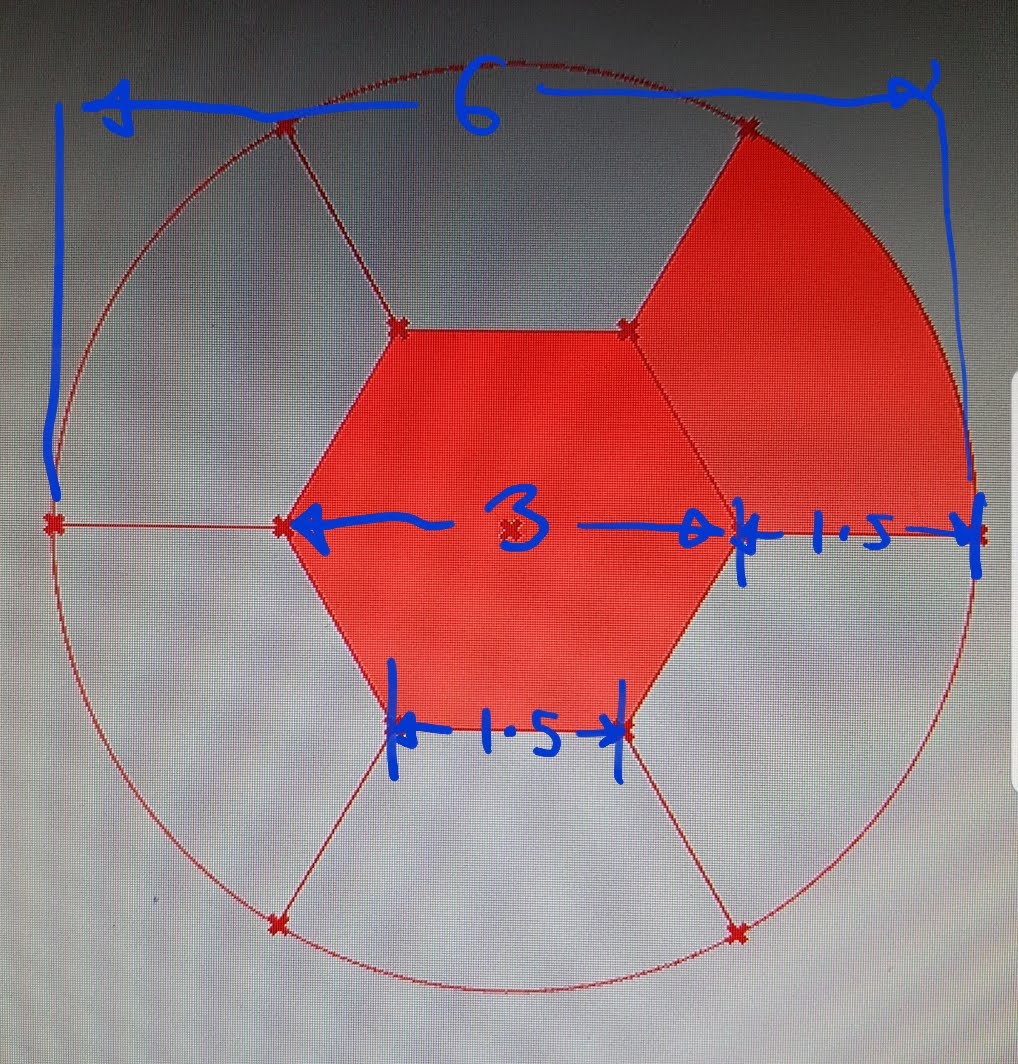
We were commissioned to design and construct a circular stage for a Cyr wheel performance in Gifford's Circus. The stage had to meet several requirements: it had to have a diameter of 6 meters, be able to be disassembled into pieces small enough to fit through a door with a width of 2.6 meters, be able to support the weight of performers, be easy to assemble by two people in a short amount of time (with each panel weighing no more than 50kg), be flat and level on rough ground, and be durable enough to withstand the rough handling and moisture of circus life.

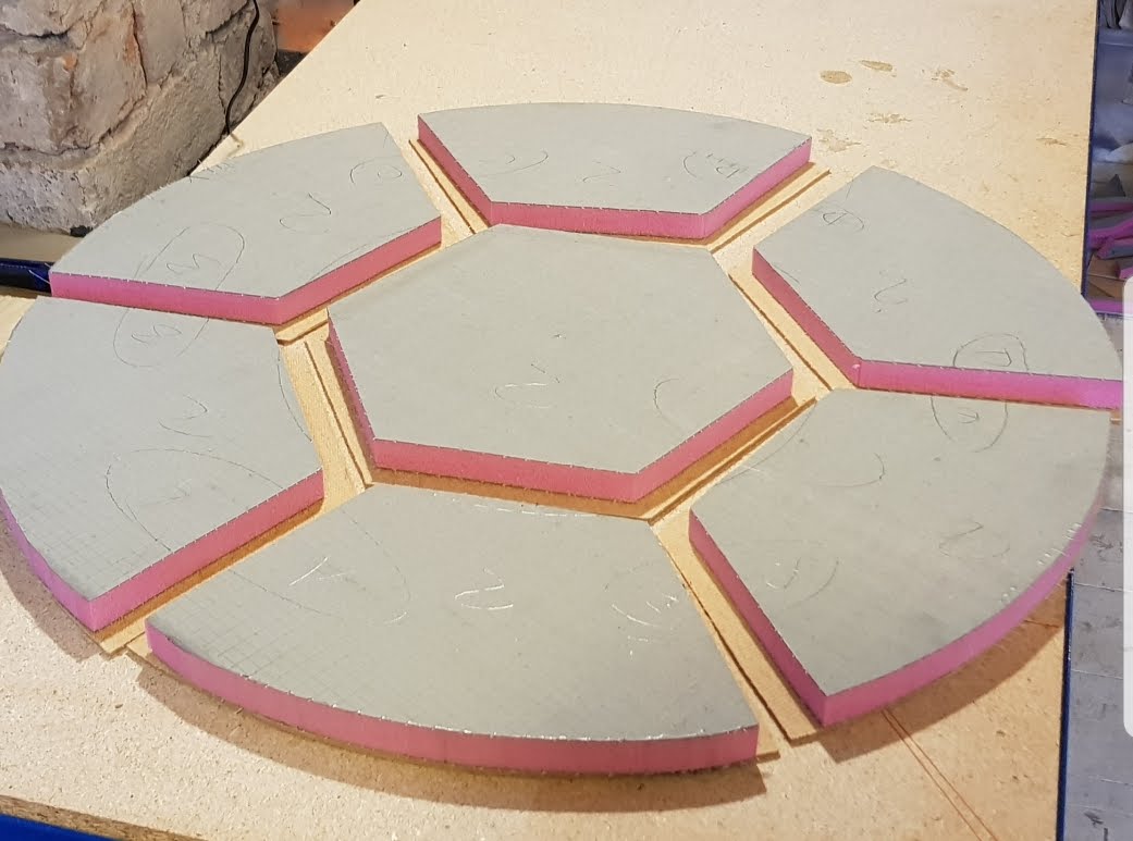
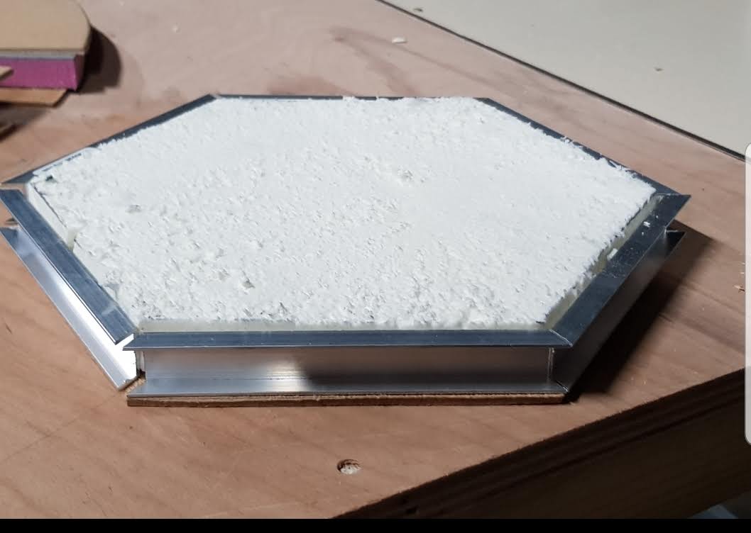
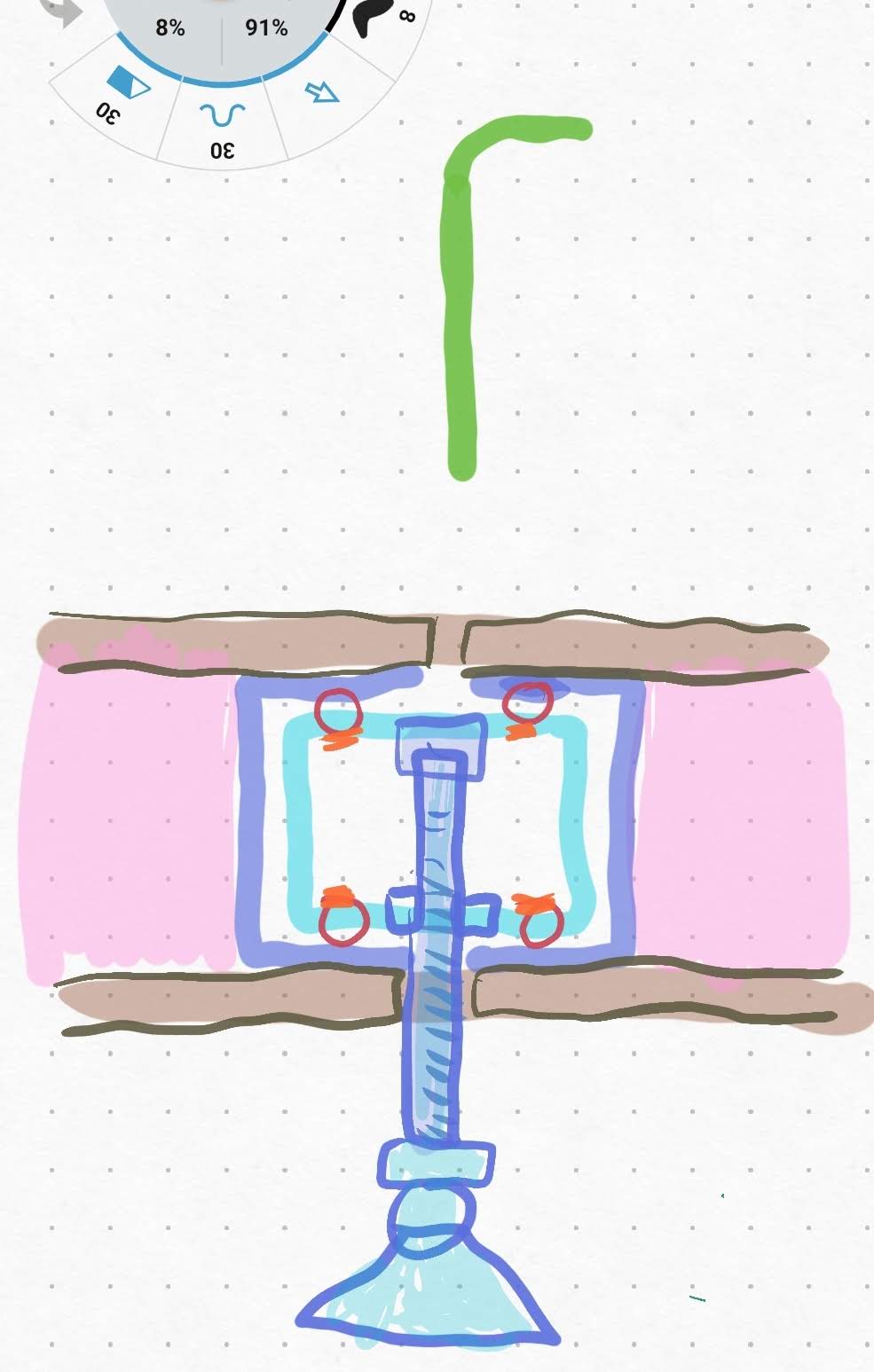
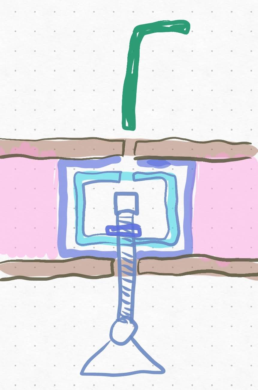
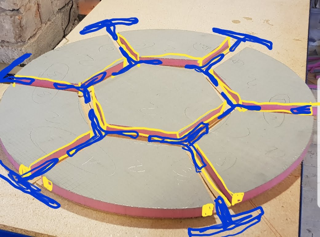
To achieve these goals, we considered various designs for the circle and ultimately settled on a composite panel made of an XPS core sandwiched between two layers of extra durable fibreglass, with a non-slip coating. The material was cut into the necessary shapes using a hot wire cutter with a rectangular profile, and the foam was removed from the mating edges, leaving only the outer fibreglass material. Adhesive was applied and aluminum extrusion was pressed into the edges of the panels. The aluminum provided protection for the edges, supported the edges to prevent deflection, and provided slots for the removable leg structures that connected the panels together.

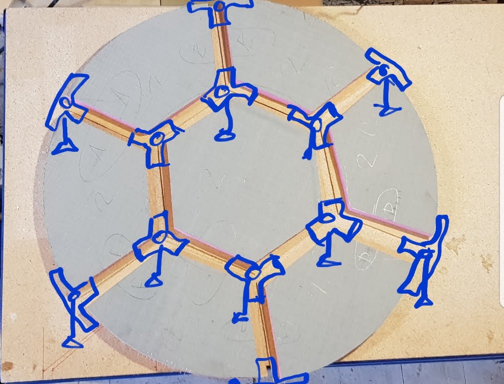
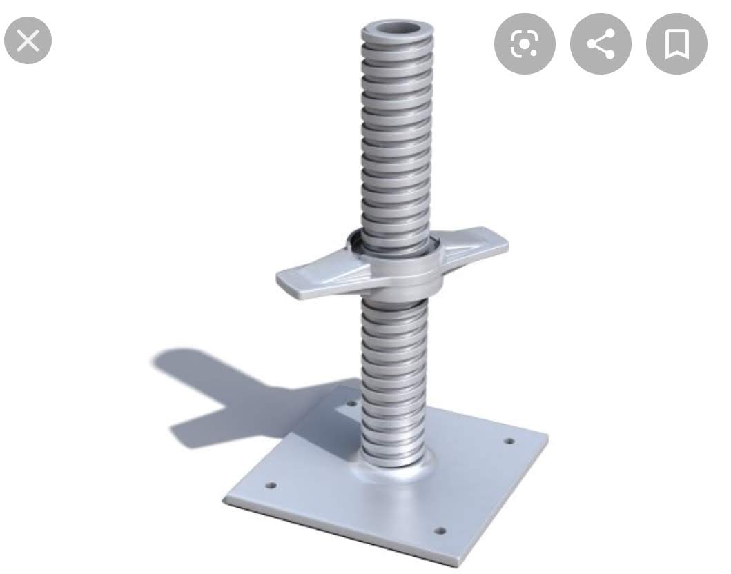
The leg structures were placed at the intersection of three panels and consisted of three pieces of steel box section fitted within aluminum U channels and welded at 120-degree increments to form a three-directional cross. A hole was left at the intersection, into which a threaded tube was welded. An internal hex bolt or long grub screw with a foot plate on the bottom was threaded into the tube and could be adjusted from above through a small hole in the stage using an allen key bit on an impact driver. This arrangement allowed for a quick and easy assembly process, with the legs being extended until they touched the ground to level the stage. The pieces were held together with inner steel box sections curved on the outer curved edges, and a large ratchet strap was used to wrap around the entire structure and compress the circle inward, pulling all the pieces together.

Overall, the design and construction of the circular stage was a challenging but rewarding project. We were able to meet all of the requirements set forth by the client and create a stage that was durable, stable, and easy to assemble and transport.

Docusaurus Plushie

Docusaurus Plushie Docusaurus Plushie

Docusaurus Plushie

Docusaurus Plushie

Docusaurus Plushie

· 2 min read

The Royal Windsor Horse Show is an annual event that attracts thousands of visitors and is the largest outdoor horse show in the United Kingdom. In order to ensure that the event runs smoothly, it is important to provide reliable connectivity to the staff and trader areas.

To achieve this, our team deployed a wireless network on the show grounds and created a heat map by taking geolocated signal strength readings on a smartphone from all over the site. This data was then uploaded into ArcGIS and used to create a heat map, which highlighted areas with weak signal strength or wireless black spots.

To help visualize the network and identify any potential issues, the heat map was overlaid on a georeferenced site map that showed the locations of wireless access points, cable routes, and network switch locations. By using this information, we were able to ensure that the staff and trader areas had the necessary connectivity to support the needs of the event.

Overall, the deployment of the wireless network at the Royal Windsor Horse Show was a success and played a vital role in the smooth running of the event. We are proud to have been able to support the needs of the staff and traders and help make the event a success.

Docusaurus Plushie

· 3 min read

The Isle of Wight Festival 2019 was a large-scale event that took place at Seaclose Park on the Isle of Wight. With 3km of arenas and fields to cover, the deployment of the network was a massive and complex undertaking. To ensure that the site was properly connected, network cabinets were set up in each arena and connected with miles of fiber optic cable. These cabinets were then connected to multiple ADSL connections that were bonded together, providing a robust and reliable internet connection.

To provide connectivity within each arena, smaller network switches were located within 100m of the cabinets. Locations that were beyond this range were connected with wireless point-to-point links, which were either mounted on poles attached to the sides of tents or beam out across the arena from wireless sectors mounted on cherry pickers. These signals were then picked up at distant locations through wireless point-to-point receivers attached to the sides of tents.

In addition to the network infrastructure, the event also required a comprehensive CCTV system to ensure the safety of attendees. To this end, at least one cherry picker equipped with a pan-tilt-zoom CCTV camera was stationed within each arena, with additional cameras installed on scaffolding poles, gateway arches, and stage sides. WiFi was also provided in the crew and camping areas, and temporary offices were equipped with temporary WiFi and VoIP phones for both internal and external communication.

To aid in the deployment and management of the network, we utilized a number of tools and resources. For example, we used QGIS's 'Align Raster' tool to georeference a high-definition image of the site map, which we then uploaded to Mapbox and used to create a basic Leaflet.js web map. This map used the host phone's geolocation to position a marker, helping us to determine our exact location on the site and identify which tents required connectivity. We also used the 'Map Marker' app on Android to quickly locate network devices as we deployed them.

After the event, the map was used to quickly locate and retrieve all of the equipment. This was particularly useful as the staff members who investigate faults or retrieve hardware after an event are often different from those who deployed it, making it difficult to locate the devices without a detailed and up-to-date map showing their locations and connections. By using this map, we were able to efficiently trace faults in the network and ensure that all of the equipment was properly accounted for. Overall, the deployment and management of the network at the Isle of Wight Festival was a successful and complex endeavor that helped to ensure the smooth operation of the event.

· 2 min read

The web application we developed allows users to access and update the location data for network devices. When the location of a device needs to be recorded, the user simply enters the device's MAC address into the app. The MAC address is then checked against a list of available device MAC addresses in the database to verify its authenticity. If the MAC address exists in the database, it is marked as "deployed" and the coordinates of the user's phone, on which the update was made, are added to the latitude and longitude columns. If the MAC address is entered incorrectly or does not correspond to a device in the database, the app user is notified and asked to enter a different MAC address.

The deployed devices are displayed on a map in real-time, allowing users to easily view and locate them. Each device can be clicked on to view information such as its device type, MAC address, IP address, and more. Users also have the option to select a device for deletion, which changes the corresponding value in the "deployment status" column to "false" and removes the latitude and longitude position values from the database.

To aid in testing and debugging the app, we also developed a BASH script that produces fake data for testing purposes. This script generates a CSV file containing random MAC addresses, asset tags, device models, and locations, which can then be uploaded to the database for testing purposes. By using this script, we were able to simulate different scenarios and ensure that the app was functioning correctly before deploying it in a live environment.

#!/bin/bash

# Generate 100 random devices
for i in {1..100}
do
# Generate a random MAC address
mac=$(c=0; until [ $c -eq "6" ]; do printf ":%02X" $(( $RANDOM % 256 )); let c=c+1; done | sed s/://)

# Generate a random asset number
asset=$(( $RANDOM % 9999 + 1000 ))

# Choose a random location from the locations.txt file
location=$(shuf -n 1 locations.txt)

# Choose a random model from the models.txt file
model=$(shuf -n 1 models.txt)

# Output the device information to a CSV file
echo "$asset, $mac, $model, $location"
done > devices.csv

· One min read

Rewilding involves the restoration of natural habitats in areas that have been modified or degraded by human activity. One way to identify suitable areas for rewilding is to search for topographic areas that are characterized by natural environments. This can be achieved through the use of a SQL query to search for rows in a database table where the value "Natural Environment" appears in the "descriptivegroup" column. This column likely contains an array of descriptive tags or categories for each topographic area.

The results of this query can inform planning and conservation efforts by identifying areas that are potentially well-suited for rewilding. These areas could provide corridors for wildlife movement through urban environments and enhance biodiversity in these areas. By prioritizing these areas for restoration and rewilding, it is possible to improve the connectivity of natural habitats in urban areas and promote the health and well-being of these ecosystems.

SELECT *
FROM topographicarea
WHERE 'Natural Environment' = ANY (descriptivegroup)

Docusaurus Plushie

Docusaurus Plushie

You can see how the edges or roads and railway tracs could be used as wildlife corridors.

Docusaurus Plushie

· 2 min read

At the Bath Festival, a small deployment of access points was placed around the tents to provide WiFi connectivity to attendees. In order to maximize coverage and ensure reliable connectivity, each access point was connected to a sector on an adjacent building via a point-to-point wireless link. In addition to the wireless link, each access point was also connected to a ADSL line and a temporary satellite on the roof to provide multiple redundant Internet connections.

To assess the performance of the access points and identify any areas with weak signal strength or wireless black spots, we used an Android app to collect a series of geolocated signal strength data points. These data points were formatted in Excel and then uploaded into ArcGIS, where a tool was used to create a heat map. This heat map was then overlayed over the site plan to provide a visual representation of the signal strength across the festival grounds.

By collecting and analyzing this data, we were able to identify any areas with weak signal strength or wireless black spots and take steps to improve coverage in these areas. This ensured that attendees were able to access the WiFi network and stay connected throughout the duration of the festival. By using a combination of a point-to-point wireless link, a ADSL line, and a temporary satellite, we were able to provide reliable and redundant Internet connectivity to the festival attendees.

· 2 min read

Inspired by the idea of using natural building materials, we set out to explore the unique characteristics and personalities of each material and use them in innovative ways in our design. We wanted to capture the mood and atmosphere of the natural environments where these materials are typically found, such as the underground world of stone and water or the airy heights of wood.

To this end, we experimented with lightweight hazel structures as a way to combine wood and air in our design. We were particularly interested in the underground world of stone and water, and decided to dig a tunnel into the side of a hill to see what we could discover. Unfortunately, the largest cavity we found was only two feet wide, and we had to come up with a different solution to support the roof of the tunnel. We ended up building concrete block load-bearing walls with concrete lintels supporting the stone above, which took up a lot of space and lost some of the rustic charm of our original design, but was necessary for safety.

According to our cross-sectional diagram, there is a third layer between the stone and wood in our design - a thin layer of mud from which all life springs. While we have not yet conducted extensive research on using mud as a building material, we have done extensive research and design work on the organic life that it can support. In our design, we envision the wood as the ideal location for sleeping quarters, warm and dry in the loft, while the ground floor would be reserved for the kitchen, toilet, and other organic activities, including food production. There may also be some kind of underground stone cavernous space beneath the building for an as-yet-unknown purpose.

Overall, our goal in this project was to use natural building materials in unique and innovative ways that captured the mood and atmosphere of the natural environments where these materials are typically found. While we encountered some challenges along the way, the process was exciting and rewarding, and we are proud of the design we have created.

· 2 min read

In order to assess the flood risk of Pudding Brooke, we first imported Digital Terrain Model LIDAR tiles into QGIS and used them to create contour polygons at 0.25m intervals. These contour polygons were then styled using a graduated color scheme, with each polygon being colored based on its elevation. This allowed us to easily visualize the topography of the area and identify areas that were prone to flooding.

After creating the contour polygons, we selected potential sites for outbuildings in appropriate high ground locations. This was an important step in the flood risk assessment process, as we needed to ensure that any new structures that were built would be situated on high ground and therefore less vulnerable to flooding. To identify suitable locations for outbuildings, we carefully evaluated the contour polygons and selected sites that were located on the highest ground available.

Overall, the use of Digital Terrain Model LIDAR tiles and contour polygons was essential in helping us to accurately assess the flood risk of Pudding Brooke and identify suitable sites for outbuildings. By carefully analyzing the topography of the area, we were able to make informed decisions about where it was safe to build, ensuring that any new structures would be protected from potential flooding.

Docusaurus Plushie

· 2 min read

Our team has an innovative idea for a self-sustaining salad bar that utilizes vertical space to meet production needs. We propose planting seedlings in a steel cable reinforced fiber matting that hangs vertically above the counter. This matting would be supported by two large drums at the top and bottom, and would be able to rotate at a speed calculated based on the height of the assembly, the maturation time of the chosen crop, and the desired harvesting frequency. This way, a seedling planted at the bottom would be ready for harvest by the time it reaches the top and returns to the bottom. With this system, the salad bar would be able to achieve perpetual harvesting, meeting its demand for fresh produce without having to rely on traditional terrestrial agriculture methods.

In addition to this innovative planting system, we also propose supplying the plants with dissolved nutrients by producing an ultrasonic fog in the chamber between the two planting surfaces. This would help to ensure that the plants have all the nutrients they need to grow and thrive. To maintain a stable temperature for the plants, we suggest using a vertical poly tunnel in colder climates to protect them from temperature fluctuations.

Overall, our self-sustaining salad bar concept would be a revolutionary way to meet the demand for fresh produce in a sustainable and efficient manner. By utilizing vertical space and innovative technologies, we believe this concept has the potential to revolutionize the way that salad bars and other food establishments source their produce.

· 2 min read

When designing a building, it is important to consider the building as an organism that has a symbiotic relationship with its occupants. This means that the building should be organized like a system of interdependent organisms, with each organism fulfilling a specific function within the larger structure. By treating the building as an organism, we can create a dynamic and self-sustaining ecosystem that supports the health and well-being of its occupants.

There are many different types of organisms that can be incorporated into the design of a building. Some examples might include microalgae, which can be used for wastewater treatment and oxygen production; vermiculture, which can be used for composting and soil improvement; fish, which can be used for food production and waste management; guinea pigs, which can be used for research and education; leafy green plants, which can be used for air purification and aesthetics; and bacteria, which can be used for biological processes such as fermentation and nutrient cycling.

The building itself should function like a shell or frame that provides a home for these organisms. By using environment-specific creatures, it is possible to keep different systems separate, creating an urban jungle inside the building. This approach allows for the creation of a diverse and self-sustaining ecosystem within the building, providing numerous benefits to the occupants such as improved air quality, food production, and waste management. By considering the building as an organism with a symbiotic relationship with its occupants, we can design buildings that are more dynamic, self-sustaining, and supportive of human health and well-being.