Land registry price paid parcels
We combined three separate files containing price paid data into a single file, removed unnecessary quotes, selected only rows that contained the string "GL" followed by a number between 0 and 9, and printed out only the fourth and second columns. We also added column names and deleted any rows that contained null values.
$ cat pp-2018.csv pp-2019.csv pp-2020.csv | tr -d '"' > pp_3year.csv \
&& awk -F"," '/GL+[0-9]/ { print $4 "," $2}' pp_3year.csv > gl_p_3.csv \
&& { echo "postcode, pounds"; cat gl_p_3.csv; } > prices.csv \
&& sed -i '/\\N/d' prices.csv
Prepare location data
We used the same process to clean and filter the data as we did for the price data, except we did not need to concatenate multiple files together.
$ awk -F"," '/GL+[0-9]/ { print $1 "," $8 "," $9}' open_postcode_geo.csv >
gl_l.csv \
&& { echo "postcode, latitude, longitude"; cat gl_l.csv; } >
coordinates.csv \
&& sed -i '/\\N/d' coordinates.csv
Import parcels
We used ogr2ogr to convert a file containing cadastral parcel information (in GML format) into a PostgreSQL file, changed the projection of the data from OSGB to WGS84, and imported it into a database.
ogr2ogr \
-f "PostgreSQL" \
-a_srs "EPSG:27700" \
-t_srs "EPSG:27700" \
-nln parcels \
-progress \
PG:"dbname='postgres' host='0.0.0.0' port='5432' user='postgres'
password='postgres'" \
Land_Registry_Cadastral_Parcels.gml
Connect to server
set psql password
export PGPASSWORD=postgres
We started a psql session on the client computer to allow us to communicate with the database that is stored on the server.
psql -h 0.0.0.0 -U postgres
Create prices table
We created a new empty table with a primary key column of type serial (which will automatically increment) and two additional columns: one for text data (postcodes) and one for integer data (pounds).
CREATE TABLE prices (
p_prices_id serial PRIMARY KEY,
p_postcode TEXT NOT NULL,
pounds INTEGER NOT NULL
);
Create location table
We created a similar empty table for storing location data, but with columns for latitude and longitude rather than a column for pounds.
CREATE TABLE coordinates (
c_id serial PRIMARY KEY,
c_postcode TEXT NOT NULL,
latitude FLOAT NOT NULL,
longitude FLOAT NOT NULL
);
Populate prices table
We used the \copy command in psql to import the price data into the new price column in the database.
\copy prices(p_postcode, pounds) FROM '/home/reuben/Downloads/prices.csv'
DELIMITER ',' CSV HEADER;
Populate coordinates table
We repeat the process for the coordinates data.
\copy coordinates(c_postcode, latitude, longitude) FROM
'/home/reuben/Downloads/coordinates.csv' DELIMITER ',' CSV HEADER;
Join coordinates and prices into points
We used the JOIN command in SQL to create a new table that combines the prices and coordinates data based on their shared postcodes.
SELECT
c_id,
c_postcode,
latitude,
longitude,
pounds
INTO points
FROM coordinates INNER JOIN prices
ON coordinates.c_postcode = prices.p_postcode;
Add geometry column to points
We added a new column to the table to store geometry data.
ALTER TABLE points ADD COLUMN geom GEOMETRY(Point, 4326 );
Update points from coordinates
We used the data in the latitude and longitude columns to create points and stored them in the geometry column.
UPDATE points SET geom = ST_SETSRID(ST_MakePoint(longitude,
latitude), 4326 );
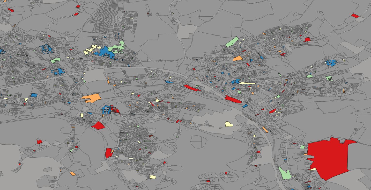
Create priced polygons
For each point within a polygon, we created a new polygon and added the corresponding price paid for the point to it.
SELECT
c_id,
parcels.wkb_geometry,
points.pounds
INTO polygons
FROM
parcels INNER JOIN points
ON st_contains(parcels.wkb_geometry, points.geom);
Find avarage point value for duplicate polygons
We calculated the average value for each of the duplicate polygons.
SELECT c_id,geom,avg(pounds)
INTO avg_polygons
FROM polygons
GROUP BY geom;
Import new price paid polygons to file
We used QGIS to export the table from the database.
Qgis > Database > DB Manager > Import Layer/File - Name: avg_polygons
Add price paid polygons layer to Qgis
Displaying the layer in Qgis.
Qgis > Layer > Add Layer > Add Vector Layer
Qgis > Database > DB Manager > Import Layer/File - Name: avg_polygons
Vector Dataset(s): .shp
Colour polygons by attribute field
We modified the layer properties in order to create a visually appealing effect.
Right click: Layer > Properties
Symbology > Single Symbol: Graduated
Value: pounds
Colour Ramp: Spectral
Invert Colour Ramp
Segmentation: Equal Interval
Download data
We downloaded a CSV file that contained property price data for the past three years, along with the postal code coordinates and boundary line polygons.
$ wget bdline_gpkg_gb.zip
&& unzip bdline_gpkg_gb.zip
&& cd data
Import bdline
We used ogr2ogr to convert a file containing boundary lines (in a format called GeoPackage) into a PostgreSQL file, changed the projection of the data from OSGB1936 to WGS84, and imported it into a database.
ogr2ogr \
-f "PostgreSQL" \
-a_srs "EPSG:27700" \
-t_srs "EPSG:4326" \
-progress PG:"dbname='gis' host='$ip' port='5432' user='$user'
password='$password'" \
bdline_gb.gpkg
Connect to server
Starting a psql instance on the client in order to interact with the database on the server.
psql -h 192.168.88.10 -U postgres gis
Create priced paid polygons for every point
We used point data that was already in the database from a previous project to create a new polygon for each point that was within the boundaries of a parish. We also added the price paid for each house (the point) to the corresponding polygon.
SELECT
parish.geom,
points.pounds
INTO pp_parish
FROM
parish INNER JOIN points
ON st_contains(parish.geom, points.geom);
Find avarage point value for duplicate polygons
Like in the the previous project, we calculated the average value for each of the duplicate polygons.
SELECT geom,avg(pounds)
INTO avg_pp_parish
FROM pp_parish
GROUP BY geom;
Import new price paid polygons to file
Qgis > Database > DB Manager > Import Layer/File - Name: pp_parish
Add price paid polygons layer to Qgis
Qgis > Layer > Add Layer > Add Vector Layer
Qgis > Database > DB Manager > Import Layer/File - Name: pp_parish
Vector Dataset(s): .shp
Colour polygons by attribute field
Right click: Layer > Properties
Symbology > Single Symbol: Gradiated
Vaule: pounds
Colour Ramp: Spectral
Invert Colour Ramp
Segmentation: Equal Interval